Engaging Getaways and Venues for:
USA/Mid-Atlantic: Highland Lakes, NJ
Time: 3 1/2 hours
Distance: 6 miles
Viewpoint: The best place to picnic is next to the lake before or after the walk. You can also picnic on the mountaintop at Waypoint 2 or at the picnic tables in Waypoint 9.
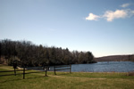
From the state park’s parking lot, walk past a playground and follow a gravel path to the left. Pass through a small patch of woods with a lake and a picnic area to your right. Proceed past a boat-rental area and back into the woods, keeping the lake and picnic tables to your right.
 At a junction, bear right. Go through a gap in a split-rail fence by a “Wingdam Trail” sign. The stone ruins to your left are the remains of the 19th-Century iron-smelting town of Double Pond. Eight tons of pig iron were produced daily when the town’s furnace ran smoothly. Proceed across the top of a dam with the lake to your right. At the far side of the dam, ignore a trail to the left. Continue straight uphill along the blue-blazed Wingdam Trail. Ignore a small trail to the right. Continue on for about five minutes. Ignore another small trail to the right just before you emerge from the woods by the lake.
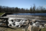 Pass over a bridge with a dam to your right and a waterfall to your left. Continue on the blue-blazed trail as it ascends through the woods. Ignore a small trail to the right. Follow the blue-blazed trail as it winds back and forth and makes a steep ascent up a small mountain. You reach the mountaintop about 20 minutes after leaving the bridge.
Veer to the left down the mountain following the blue-blazed trail.
At a junction with the yellow-blazed Laurel Pond Trail, turn right and follow the yellow blazes for 20 or 25 minutes. (If you want to shorten the walk, turn left at Waypoint 4 and follow Laurel Pond Trail until it rejoins the walk at Waypoint 10.)
At a trail head (three yellow blazes on rocks), turn left onto black-blazed Cherry Ridge Rd. Continue on for about 10 minutes. Pass over a wooden bridge. Follow the road as it curves uphill to the right.
 About five minutes after you cross the bridge, you reach an intersection with Old Coal Trail (marked by three red blazes). Bear left. You are still on Cherry Ridge Road. In a few minutes, you pass another red-blazed trail to your left. Ignore it. Continue following the black blazes. Cross over a creek on a wooden bridge and continue with wetlands to your right. Cross over a stream, using stepping stones. Pass some red gate posts. Follow Cherry Ridge Road uphill until you reach a pair of yellow gate posts with a cable strung between them. Walk around the gate.
Shortly after you pass the gate, you reach a rotary and a small parking area. Opposite the parking area, to your left, is the trailhead for Banker Trail, marked by three yellow blazes. Turn left and follow Banker Trail (marked by weathered yellow blazes and newer green blazes) through the woods. Pass by swamp land to your left.
 You soon reach a junction of Banker Trail and Cedar Swamp Trail. Bear left and follow the blue-blazed Cedar Swamp Trail. The trail will soon narrow and wind its way through several stands of rhododendron, some so thick that they form tunnels. You may have to use stepping stones across a small swampy area. Savor the feeling of walking through what feels like a tropical rain forest in northern New Jersey. After about 30 minutes, you walk across numerous planks, passing through a large swamp. Continue through the woods on the blue-blazed trail for another 10 minutes.
At the end of the blue trail, proceed straight onto a yellow-blazed trail (Double Pond Trail) and follow it as it curves to the left. Be careful on the muddy stretches of the trail. Continue straight (past a red trail on your left). Pass over a wooden bridge. After about 15 minutes since you joined the Double Pond Trail, you reach a gate. Walk around the gate and continue on the trail into a picnic area. Proceed on the trail as it circles through the picnic area and joins a dirt road. Bear right and follow the road over a wooden bridge across a stream.
 Just past the bridge, by outhouses and a small parking lot, there is an intersection of several trails with the dirt road. Follow the road briefly as it turns to the right. Then bear left, leaving the road. Follow a trail that winds uphill, with a huge stone furnace to your right and a stone wall to your left. This is Wawayanda Furnace, where iron was produced in the mid-19th Century. Cross over a wooden bridge. On your left are the stone ruins that you saw in Waypoint 1. Continue straight and retrace your steps back to the parking lot.