Engaging Getaways and Venues for:
USA/Mid-Atlantic: Piermont, NY
Time: 1 1/2 hours (for the 3-mile walk)
Distance: 3 miles or 5 miles if you include a walk to Piermont.
Parking: The main picnic area has ample parking.
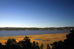
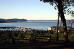
Viewpoints: Beautiful views when you park and when you begin the return trip along the loop. There are wonderful picnic spots.
Precautions: The trail is mostly level with a few steep, rocky grades. It leads near cliff tops for quite some time on the return trip. Rock outcroppings are excellent picnic spots but watch out: A fall would be fatal. The walk into Piermont includes a short but steep grade and adds enough distance to increase the rating to Moderate should you do the extension.
Trail blazes: You follow the turquoise-blazed Long Trail for much of the way, although there are some unblazed portions.
Maps: The New York-New Jersey Trail Conference publishes excellent maps of Tallman State Park. They can be found in outdoors shops, some book stores, and online at www.nynjtc.org.
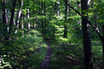
 Proceed from your car down the paved road, looking for the turquoise blazes of the Long Path on trees along the road. The river will be to your left. Follow the blazed trail as it proceeds down into the forest, away from the road. It's just a short walk through the woods to Waypoint 1.
When you reach a paved road, proceed downhill on a little paved path that leads toward a park pool.
In a short distance, go right, following the turquoise blazes into the forest. Cross a bridge and proceed straight up a steep hill. At the top of the hill, you see beech trees with carvings from the 1950s. Follow the blazes to the left of picnic areas and a stone shelter. Keep looking for trail blazes, because the trail zigzags through a relatively open forest. After a short while, the trail leads to the escarpment above the Hudson River. You're now on an old farm road that could easily date to the 1700s.
Just after the trail veers sharply to the right, it crosses a paved bike trail and leads onto an old berm, which was part of an oil-tank store facility that a local industrialist planned to build in the early 20th Century.
 The trail veers sharply left onto another berm, still following the turquoise blazes of the Long Path. Notice numerous dikes and other odd earthworks now covered by forest.
When you reach a bike path, go left onto the path in front of some ruins. You have now left the turquoise blazes of the Long Path. In the valley below to your right, mostly obscured by forest, is the historic and now exclusive enclave of Sneden's Landing. Follow the bike path as it veers to the left. Ignore several unmarked trails that lead into the forest on your right.
 About 100 yards after the bike trail has curved back to the north, go right onto a footpath leading straight into the forest toward the cliffs above the river. There are several viewpoints along this part of the walk, but be very careful.
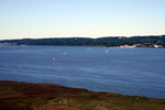
At a three-way intersection on the cliff top, with the river in front, go left. The river is on your right. You soon reach an overlook offering splendid views of the river, the villages of Irvington-on-Hudson, Dobbs Ferry, Hastings-on-Hudson, the city of Yonkers, and the George Washington Bridge, far to the right. Be very careful — the cliffs are very steep.
Continue on the old footpath along the cliff top. These lands undoubtedly were farmed in colonial days but have returned to forest. After curving to the left, the old, unmarked path intersects the turquoise-blazed Long Path at Waypoint 3, an intersection with the bike path. Go right and retrace your steps, following the blazes of the Long Path back to your car.
To visit the village of Piermont, get into your car and drive out of the park. Make a right and follow the signs into town. Or, if you’d like to remain on foot, proceed north following the Long Path blazes down a steep hill, onto a dirt road, and then onto a paved road leading into town. This hill is steep and can be muddy. If one or more in your party plans to have a drink or two, don’t forget you’ll have to make the short but steep climb back up. Here are the walk directions to Piermont.
 Follow the turquoise Long Path down a steep hill at the north end of the parking lot. There’s a nice view of the Tappan Zee Bridge. At the bottom of the hill, turn left on a dirt road. When you reach a paved road, Ferdon Avenue, turn right and follow it. Cross a small river and proceed on the Long Path to the intersection with Paradise Avenue and Piermont Avenue. Proceed straight to Piermont Avenue toward town.
You can go right here by car or on foot down Gair Street to visit the pier. Make a right on Ferry Road and proceed as far as you wish.