Engaging Getaways and Venues for:
USA/South: Chattanooga, TN
The Highlights: An historic, easy to navigate, revitalized city surrounded by picturesque hills; a world-class aquarium, museums and sophisticated restaurants and hotels; a 19th-century bridge open only to pedestrians, and a 13-mile bike path along the Tennessee River.
Other Places Nearby: Civil War battlefields with excellent trails for walkers; Prentice Woods State Park, the Tennessee River Gorge, and numerous options for kayaking, fishing, hunting and hang-gliding.
Meetings & Event Options: Small town convenience and service with big-city facilities, including a convention center surrounded by boutique and chain hotels, as well as numerous historic and creative locations for business and social events.
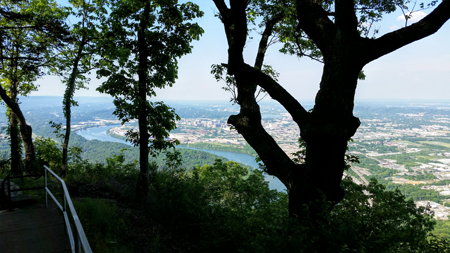
Chattanooga View from Lookout Mtn.
If there is any single spot in the U.S. from which you can see almost the entire sweep of our history, the majesty of our land, the ingenuity of our people, the apex of our tragedies and our redemption, it’s from the overview at Point Park on Lookout Mountain, just across the Tennessee River from downtown Chattanooga.
Below you, on this spot where a strategic Civil War battle was fought, you will see the city nestled in a sharp bend in the Tennessee River surrounded on three sides by steep hills, whose geography and location created unique opportunities and challenges for the people who live here that in many ways epitomizes the American experience. A visit to Chattanooga is to experience the essence of the U.S.A.
The Tennessee becomes a major river in a remarkably short distance from its source, just 130 miles or so to the north. By the time the river gets near Chattanooga on its 659 mile course to the Ohio, it runs into a series of low ridges around which it has cut improbably sharp curves against steep cliffs, forming a series of elbows—one of which cradles the city of Chattanooga.
The area’s lush forests and the river must have provided more than ample sustenance for the Cherokee, who roamed this land long before Europeans arrived and Chattanooga emerged as a trading community between the Native Americans and settlers in the early 1800s. You can experience a taste of what this land was like in those days by taking a walk or hike through Prentice Cooper State Forest, less than a half hour’s drive from downtown, whose steep hills are covered with dense forest. See Outdoors.
Few 19th Century inhabitants would have guessed that this sleepy trading post would become strategic to U.S. history, located as it at the junction of four gaps in the mountains, providing access to travelers heading northwest, northeast, southeast and southwest. The region’s geography figures significantly, not only in the history of Chattanooga, but in that of the U.S., because it was in this area that many historians believe that the fate of the Confederacy was sealed during the Civil War, about nine months before the more well-known battles of Gettysburg or Vicksburg.
The city of Chattanooga is fairly young, even by American standards. The area’s original population consisted of Cherokee, whose Chief in the early 1800s, John Ross (also known as Guwisguwi), established his tribal center in what is now downtown Chattanooga around 1816. Chattanooga first entered the history books in 1838 as the departure point for the infamous Trail of Tears, which is marked by a memorial on the bank of the Tennessee River adjacent to the Chattanooga aquarium. From this point, about 15,000 Cherokee Indians were forcibly marched to reservations in what is today Oklahoma. Over 4,000 died along the way.
The city experienced its first burst of growth in the 1840s and 1850s based on the expansion of river traffic and the creation of a railroad hub that would have an important role to play in the Civil War. Even then, only about 2,500 white settlers inhabited the place at the outbreak of the conflict. Trains gave the city enduring fame in 1941 with the Glenn Miller Band’s hit, “Chattanooga Choo-Choo,” spawning a tourism attraction that lives on to this day—the Chattanooga Hotel and Museum, where train buffs can spend the night in a restored historic train car.
It was in large part because of its trains that Chattanooga’s indelible role in American history was forged. With its strategic location offering a rail and river transport center with access in every main direction to supply the army, Chattanooga’s location made it the center of the Union Army’s overall three-pronged strategy to subdue the south. While the Army of the Potomac would advance from the east to take the Confederate capital of Richmond, VA, and the Army of the Tennessee would move first southwest to take key cities of Vicksburg, MS, and New Orleans and then move east across the deep south, the Army of the Cumberland would take Chattanooga and then move south to Atlanta, a key to the heartland of the Confederate economy. From there it would move east to the coast of Savannah, GA, to strangle the Confederacy, then move north to join the Army of the Potomac. The Confederates had to hold the city of Chattanooga to prevent the Yankees from establishing the access and supply base necessary for the invasion of the Deep South that eventually lead to Gen. William Tecumseh Sherman’s destruction of Atlanta and his devastating march to the sea.
Chattanooga’s place in Civil War history is largely the result of a series of critical battles fought here in the fall of 1863, but as we’ll see, it ought to be just as well known for its role in the later reconciliation between northern and southern armies and the example that it set.
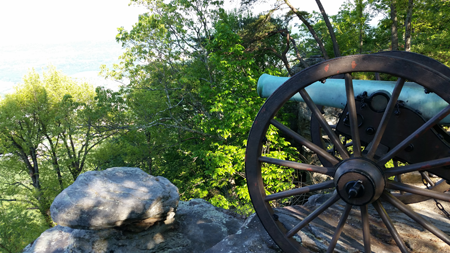
Lookout Mtn. cannon
Few cities anywhere in the U.S. have so many historic battlefields within their borders and environs. The Battles of Chickamauga, Lookout Mountain and Missionary Ridge are spread out around the city in a way that makes it remarkably easy to grasp two of the three key battles from the viewpoint at Point Park on Lookout Mountain, itself a strategic part of the campaign stretching over the fall of 1863. Given the relatively short distance between Lookout Mountain, and Missionary Ridge to the northeast, one can only imagine what this valley must have looked like teaming with over 100,000 soldiers camped in the area during that pivotal fall in the history of our nation. Compare that figure with the Chattanooga’s population of about 180,000 today. So much of the city and its surroundings were enveloped by the battles that many current residents live directly on land where major battles were fought.
No visit to Chattanooga would be complete without a visit to the Chickamauga Battlefield National Park, which combines beautiful outdoor experiences and pleasant drives with the ability to walk in forests little changed since the days of that terrible battle. It’s also an opportunity to bear witness to the monuments the soldiers who fought here later erected in memory of their friends in a spirit of reconciliation between north and south.
After being driven from Chattanooga by Union forces in the late summer of 1863, Confederate General Braxton Bragg and about 65,000 troops had to hold the Chickamauga River Valley which runs south toward Atlanta (through which now runs I-75). After pushing Bragg’s forces out of the city, Union General William Rosencrans crossed the river with his 80,000 or so troops in pursuit of the enemy. Two small parties from the opposing sides made contact near the Chickamauga River (a short distance from the recommended walk). Within a few hours, the two armies had rushed together in what was the first of three pivotal battles during that fall, this one fought mostly in dense forest. Over two days, nearly 35,000 men were killed or wounded in brutal, often hand-to-hand, combat fought in virtual chaos. Finally, a brigade of advancing Confederates found a break in the Union lines, and despite a spirited final battle led by Union General George Thomas, who became known in the North as the Rock of Chickamauga, the Union army was forced to retreat. It was a Confederate victory, but it would be their last major victory of the war.
Following the retreat of the Yankee army, Bragg’s army laid siege to the now Union-controlled city, enveloping it from the south at Lookout Mountain, where there was a canonn emplacement at what is now Point Park, all the way to the east at Missionary Ridge. You can see this historic ridge clearly from Point Park to your east, oriented north to south, and you can also walk an extensive network of trails in the hillside where the battle raged.
The siege turned into a miserable few months for the Yankees, who quickly ran low on supplies, depending mostly on small boats smuggled through Confederate lines along the river under perilous circumstances. You can visit Signal Hill, a scenic spot atop a hill west of Chattanooga from where the Yankee signal corps communicated the arrival of supplies. Here too is a great viewpoint and network of trails.
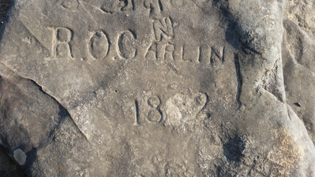
Signal Hill graffiti
In November, Ulysses S. Grant came to the rescue of the Union Army with a convoy of supplies from the north, opening up a reliable supply line to feed and equip the army by train. He also organized the campaign that would seal the fate of the Confederacy.
Grant’s first move was to capture Lookout Mountain to the south of the city, which began with a series of maneuvers from behind the mountain culminating in what became known as the Battle Above the Clouds, because of the smoke and fog that hung in the valley as the battle raged above. The Union troops eventually displaced the Confederates and captured this strategic vantage point. The area is now part of the beautiful Chickamauga and Chattanooga National Military Park and is marked with monuments erected by the soldiers who fought there—including the New York monument, said to be the only such statue on a Civil War battlefield depicting a soldier from each side shaking hands.
After capturing Lookout Mountain, Grant shifted his attention east to take Orchard Knob, a small rise east of the city facing Missionary Ridge, upon which was massed the bulk of Bragg’s army. The assault on Missionary Ridge is one of the legendary battles of the Civil War. To capture the well-defended ridge, the Yankees had to launch a frontal assault, with a flank attack by General Sherman from the north. In a fluke that ultimately helped changed the course of the war, the forces of Union General Thomas, who had already distinguished himself at the battle of Chickamauga, broke through Confederate defenses below the ridge and—without orders from General Grant—charged up the hill to find an unexpected breach in the Confederate lines. With few reserves in place the Confederate line broke, and Bragg was forced to retreat south and give up Chattanooga for good.
Chickamauga is noteworthy both for its place in war and its place in peace. Following the conflict, Northerners and Southerners alike returned to Chattanooga and together became part of a new community that prospered on account of the city’s excellent transportation network and proximity to natural resources.
In 1888, a Union veteran named Henry Boynton, while touring the battlefield with a few friends, came up with the idea to create a national park to commemorate the men on both sides who had fought there. While groups of soldiers, mainly from the North, had set up monuments at Gettysburg and a few other battlefields, Boynton envisaged a park commemorating the sacrifices of soldiers from both sides. He reached out to Confederate veterans groups, who embraced the idea. The following Veterans Day, a Blue and Gray Barbecue was held with over 20,000 attendees representing both sides. An enormous set of tables set side by side seated 12,000 veterans, with a pipe made of wood from the forests of Chickamauga set before each man. At a ceremony at which generals from both sides spoke of peace, all of the veterans lit up the pipes to “let each thought of conflict cease.” Those who attended the event spoke of men crying “like babies” as they grasped the hands of or embraced their old comrades and enemies. The next day, an organization was formed representing veterans from both sides whose efforts gave birth to the first national battlefield park in 1895 paying equal respect to the fallen of both sides. Today the Chickamauga battlefield is marked by moving statues and memorials erected by the armies of both sides, as well as signage, canon and other symbols marking the location of key areas of combat, regimental headquarters and locations of gun emplacements.
The battle around Chattanooga was so large that the government couldn’t buy up enough land to preserve it all. As a result, much of the hallowed ground of Missionary Ridge is occupied by graceful homes and stately lawns. Small “pocket” parks commemorate historic spots and the locations of the units from both sides, many of these visible on North Crest Road. Today there’s a $10 million maintenance backlog for the more than 700 battlefield monuments placed by veterans of both sides, not to mention the trail system through the battlefield which is in dire need of upkeep in various areas. (See below for how you can help preserve this precious part of U.S. history.)
Chattanooga’s history has been marked by both prosperity and great challenges, and it has addressed these with what we commonly call “American ingenuity” and a willingness to work together, as demonstrated at the initial Blue Gray Barbecue. First among its challenges was the frequent flooding of the Tennessee River, whose worst flood in 1867 brought the waters nearly 60 feet above flood stage. Floods occurred with such regularity that over the years that residents simply abandoned and filled in the basements and bottom floors of their homes and expanded above them, so that today beneath the city’s downtown is a largely unexplored labyrinth of old cellars and rooms. The worst of the flooding was not tamed until the creation of the Tennessee Valley Authority in 1933 during the Great Depression. The TVA created the system of dams and locks that have both tamed the river’s floods and provided power for millions in an enormous wave of rural electrification—but it also had a significant impact on the ecosystem of the river and endangered various species. Nonetheless, the TVA remains an important economic force in the region, and still maintains its headquarters in downtown Chattanooga.
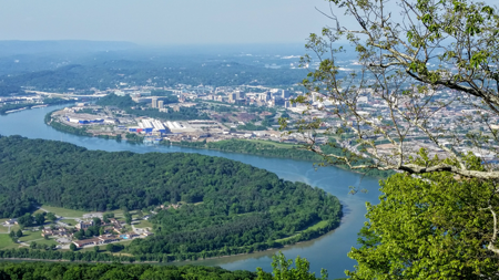
Chattanooga's location has made it vulnerable to floods
The economic success of the 20th Century brought with it terrible pollution, with smog and smoke trapped by the surrounding hills inundating the city for days at a time. As a result, the wealthy built their homes on the heights of Lookout Mountain, Signal Mountain and Missionary Ridge, well above the city, so that to this day some of the most elegant suburbs are over 1,000 feet above downtown. This industrial landscape is hard to imagine today because most of it is gone, victim to the same economic phenomenon that befell much of what has become known as the Rust Belt. In yet another sign of the ingenuity of Chattanooga’s citizens, a few dozen people in the 1980s (with the support of a local foundation) created Chattanooga Venture, a sustainable effort to engage “all of the classes and races of the city” to revive its core. The group developed 40 specific goals to be undertaken through private-public partnerships, including revitalization of the waterfront through the creation of a world-class aquarium, an art museum, a 13-mile bike trail, a completely restored 19th century bridge dedicated to pedestrians only, a free electric shuttle and paid on-street bike rental system, renovated theaters, waterfront parks and much more. Almost every project on the list has been completed, and the group remains a vital part of the city’s strategic planning process. See Things to Do, Outdoors, and Meetings for specific recommendations.
Acknowledgements:
Anthony Hodges provided details on the battles and Blue Gray Barbecue. He is President of the Friends of Chickamauga-Chattanooga National Military Park and Vice President of the Tennessee Civil War Preservation Association, groups that help preserve the battlefield sites in Tennessee. His interest in the Civil War was sparked by his family history passed down to him at a very young age by elderly relatives concerning ancestors who fought at Chickamauga.
How to Help With Battlefield Preservation
In addition to helping the Chickamauga and Chattanooga National Military Parks restore the battlefield landscape to its 1863 appearance, the Jewell Fund assists with the over $10 million in maintenance backlog of the 700 plus monuments placed by Union and Confederate veterans in key locations. Donations to the Jewell Memorial Restoration Fund can be made via the Friends website at www.friendsofchch.org or by mailing to P.O. Box 748, Chattanooga, TN 37401.